A reader writes:
I love NASA's new "Blue Marble" images. I was a kid in the early 70s when they took the first Blue Marble picture, but now the young whippersnappers all have their Google Earths and such and can all pretend to be looking out the window of a UFO whenever they want to. The magic hasn't died for me though, and now there are newer, better, brighter Blue Marbles! Three of them, from different directions!
Except in the "Western Hemisphere" one (which I found on Astronomy Picture of the Day), the USA is HUGE! It looks almost as big as the whole of Europe, Russia and China. The one that shows Australia and a lot of clouds makes it look as if Australia's the only land mass in one whole hemisphere. Africa's way too big in the "Eastern Hemisphere" one, too.
You've written about map projections before; is this something related to that? But that can't be it, there's no "projection" at all when the map of the globe is still a globe, right?
Ulricke
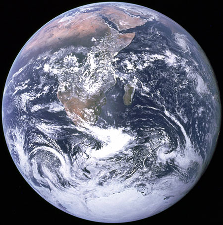
The original 1972 Blue Marble, above (the Wikipedia article has information about the 2012 version too), is what it looks like. It's a single photo, taken from a spacecraft - Apollo 17, to be exact. The famous photo was taken from a distance of about 45,000 kilometres, which is a bit higher than geostationary-orbit-distance, but well under a tenth of the distance to the moon.
(There are a lot more Apollo 17 images; they're archived here.)
The distance is important, because the earth is about 12,750 kilometres in diameter.
If you're looking at the earth from an altitude of 45,000 kilometres, you're only three and a half earth-diameters away from the surface of the planet. (If you're 45,000km from the centre of the planet, the nearest point on the planet is less than 39,000km, about three diameters, away. Keep this in mind when reading about orbits; it's not always clear whether a given distance indicates how far it is from the centre of one object to the centre of another, or the distance between objects' surfaces, or even the distance between an orbiting object and the barycentre of the orbital system.)
Shrink everything until the earth is the size of a tennis ball, and the original Blue Marble viewpoint would only be about 23.6cm (9.3 inches) away from the surface of the ball.
When you're looking at a sphere, you can never see a whole half of it at once. If you're very close to the sphere - an ant on the tennis ball - you can see a quite small circle around you, before the curvature of the sphere cuts off your view. (Actually, the fluff on the tennis ball would block your ant's-eye view much closer, but let's presume someone has shaved these balls.)
Go a bit higher up from the surface, and you can see a bigger circle. Higher, bigger, higher, bigger; eventually you're so far away that you can see 99.9999% of one half of the sphere, but you'll never quite make it to seeing a whole half.
(See also, the previously discussed optical geometry of eclipses. Shadows cast by spherical bodies are conical, and more or less blurred around the edges, depending on the size of the light source.)
If you're eight inches away from a tennis ball, you can see pretty close to a half of it, and if you're 45,000 kilometres from the earth, you can see pretty close to a half of the planet. Which is why, in the original Blue Marble, Africa looks pretty darn big, but not disproportionately so.
Now let's look at the 2012 Blue Marble.
(Note that there's also, confusingly, an unrelated other NASA thing called "Blue Marble Next Generation"; that's a series of composite pictures of the earth covering every month of 2004.)
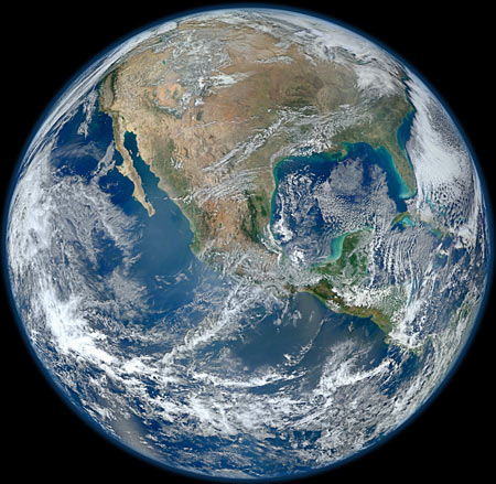
The 2012 Blue Marble was stitched together from pictures taken over four orbits by the satellite Suomi NPP, previously known as "National Polar-orbiting Operational Environmental Satellite System Preparatory Project", which was just begging for that Daily Show acronym joke.
Suomi NPP is in a sun-synchronous orbit (which, just to keep things confusing, is a type of orbit that can only exist around a planet that is not quite spherical...), only 824 kilometres up. So Suomi NPP can't see very much of the globe at any one time. But if you're compositing pictures of a planet together, you can use your composite to render an image apparently taken from any altitude you like. Provided you've got enough patchwork photos to cover the whole planet, you just have to warp and stitch them until you've covered the whole sphere. Then, you can render that sphere however you like.
For the 2012 Blue Marble images, NASA chose to render the sphere from a much closer viewpoint than the 1972 image was taken from - they say the altitude is 7,918 miles (about 12,743 kilometers). That distance is, no doubt not accidentally, about the diameter of the planet - so the virtual "camera" for the new pictures is only one tennis-ball diameter away from the surface of the tennis ball it's "photographing".
As a result, Blue Marble 2012 shows rather less than half of the sphere. But this is not immediately apparent. At first glance, it just looks as if whatever you can see is bigger than it should be.
You can experiment with this in Google Earth or any other virtual globe, or of course with one of those actual physical globes that people used to use in the 1950s or during the Assyrian Empire or something before we had computers.
Anyway, look at the real or on-screen globe from a long distance and a given feature, like for instance Australia or North America, looks as if it takes up as much space as it ought to. Zoom in and whatever's in the middle of your view takes up proportionally more of the face of the planet, as things on the edges creep away over the horizon.
So the close viewpoint of the 2012 Blue Marbles doesn't give them away as "synthetic", stitched-together images. Something else does, though.
The feature image of the new Blue Marbles - the one that showed up on APOD, and countless other sites - is the one that shows the USA. I think NASA may not have chosen that one just for patriotic reasons, though. Rather, I think it may be because the America image is the only one of the three that doesn't have noticeable parallel pale stripes on the ocean.
The stripes - most visible in the Eastern Hemisphere image of Africa (4000-pixel-square version) - are from sunlight reflecting off the water, which the Suomi NPP satellite saw on each of its orbits, and which therefore show up multiple times in the composited image. A real observer sitting in the location of the virtual camera of the new Blue Marble would only see sun-reflection on one spot on the earth, if the appropriate spot was on the water.
The 1972 Blue Marble photo was taken with the sun pretty much behind the spacecraft, so it has this one reflective highlight in the middle of the image, off the coast of Mozambique.
Psycho Science is a regular feature here. Ask me your science questions, and I'll answer them. Probably.
And then commenters will, I hope, correct at least the most obvious flaws in my answer.
13 February 2012 at 10:33 pm
>let's presume someone has shaved these balls
*snigger*
14 February 2012 at 12:23 am
All of the great photos in this article... All of the science. And I came here to say the same thing.
14 February 2012 at 4:22 am
Yep, that makes three of us.